Eminent Domain in the Moore Community of Wayne County, Missouri
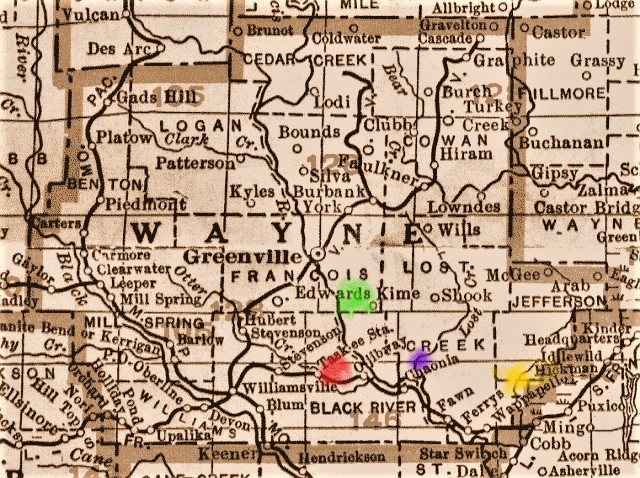
Since our next reunion is at Rucker in Wayne County, September 5, 2015, and a visit to the Moore Spring and the old home sites along Wet Fork Creek in the Ojibway Valley, I felt the subject was due some research. I believe we all will have an enhanced appreciation of our sight line from the ridge where Daniel Moore's home once gave shelter to Bessie, Ann, and Ted (Doad), across the creek valley in front in one direction and to the wooded hills in the back as a result of the research. We can only imagine at the effort and sacrifice of our ancestral Grandfathers and Grandmothers, cousins, aunts and uncles to clear this land, to work it, and reap from those efforts the bounty it provided from harvests to nurture and sustain the households of children that would grow up there... including Marie, Hank, Dee, Sylvia, Junior, Russell, Herb, and Mary and of Cecil and Beverly who would have spent time visiting their extended family there.
Eminent Domain is a controversial government edict that land can be seized at a price determined by the government to provide a better way of life for the many at the expense of the few. No thought or import is given to the sacrifices of those that owned the land, cleared it, settled it, buried their loved ones there, and made possible civilization in those locations in the first place. The impoundment of Lake Wappapello in 1941 to provide flood control along the Saint Francis River, and to provide recreational opportunities was such a project and meant that our Moore, Williams, and Dees ancestors in particular, would have to walk away from all that generations had worked to settle and build.
I do not have the specifics nailed down as to how much land John William Moore first settled in 1849 centered on the spring and the Wet Fork Creek valley. But, I would suppose it to be in the neighborhood of 80 acres. After the family's enumeration on the 1850 census. I find subsequent land acquisitions of 40 acres on 10/30/1857, 80 acres 10/30/1857, 80 acres 10/10/1859, and 40 acres 5/1/1867 for a total of 240 acres purchased after initial settlement. If we "guesstimate" the usual 80 acres at time of original land patent we can figure in the neighborhood of 320 acres as a base line. Over time the properties would be mostly owned by sons Daniel and William Dudley Moore, and 46.75 acres would be purchased by Robert Lee Dees.
In the "History of Southeast Missouri 1908" transcribed by Kim Mohler, I find the first mention of John's son, Daniel Moore's land acquisitions. In 1867 it is stated that he rented 160 acres of land "upon which he is now living." Since John W. Moore was not deceased at the time, no land would have been passed down to his heirs. Daniel would have just returned home from his discharge at Fort Leavenworth, Kansas from his Civil War and Plains duty and was beginning his family with his first wife, Margaret Sutton...the Sutton family at the time were land owners in the community.
By 1908 at the time of the writing of the book, Daniel had amassed 300 acres of owned land, 120 acres of which were cultivated. The cultivated acres are what I believe had stuck in my foggy old head from previous research. No doubt portions of Daniel's land were his share of inheritance from his father. But, Daniel was a opportunistic entrepreneur to be sure. When property became available at reasonable prices, he expanded his horizons in a factual sense.
But to come to the exact number of acres owned by our ancestors at the time of the government mandate to vacate, I felt the best thing to do was research the last Plat Map of Wayne County prior to Eminent Domain. The last plat I could locate was the plat map of 1930 and I reviewed the properties within T26 & 27N, R6E, which includes Rucker, The Moore Community proper, and Wet Fork Valley. The numbers were revealing, but, not surprising and maybe will give a little more pride and meaning to everyone that attends the September 2015 Family Reunion at Rucker. If more than one number is given it designates an additional purchased parcel of land, attached or a short distance beyond the other(s).
Daniel Moore: 40, 240, 40, 44 364 total
William D. Moore 40. 28.75, 40 108.75 total
Charles R. Moore 160 160 total
Lewis Moore 172.50 172.50 total
W. L. Moore 80 80 total
TOTAL MOORE HOLDINGS 885.25 acres
In addition, the sons of Missouri Williams, a grandmother to many to in the tree descended from the Wilson line (my great-great grandmother) still owned property in 1930. The sons were Meshack (Shack), and Abednigo (Bed), children from Missouri's second marriage to Hobart Williams. Bed and Shack still were in the Wet Fork Valley on the 1930 Plat Map.
Meshack Williams 80 80 total
Abednigo Williams 80 80 total
TOTAL WILLIAMS HOLDINGS 160 acres
Anna Moore, my grand aunt and sister to Bessie and Ted. married into the Dees family. Robert L. Dees owned land very close to Daniel Moore in the 1930 plat, and was land that at various points in time had been owned first by John W. Moore, and later by Madison Wilson, an ancestor of many in this tree.
R. L. Dees 46.75 46.75 total
TOTAL DEES HOLDINGS 46.75 total
These numbers do not account for property sold and acquired prior to 1930 of course, and if we factor in lands in the valley once owned by Wilsons, Tarltons, Wards, etc., those that also owned land and sold and moved to other geographic regions within and without the boundaries of Wayne County. the holdings probably at times in history for our family would have been much greater. But, as the 1930 plat prior to the land forfeitures of 1941, our direct ancestry accounts for 1092 TOTAL ACRES.
One last note. Adjacent to the 240 acres owned by Daniel Moore in 1930 are 160 acres with the designation of Agricultural Land. This land may have been owned by Daniel, or at the very least was a community property owned or leased, and worked by all the members of the Moore Community. IF this land is figured into ancestral ownership, the total rises to 1252 acres.
Our families fought the government by petition in court in Cape Girardeau, Missouri on April 15, 1940 to try to retain their lands and properties in Wayne County, with the result being well known, and certainly predictable. Further, on a March 15th, 1940 earlier ruling -- probably in regard for the failure to vacate as well as their submission of petition -- a court document states "that the United States of America, the plaintiff herein, be not required to deposit or cause to be deposited any sum or sums of money, or to give in any other form of security of any kind or character, to secure the payment of just compensation for the taking of said property." Since they were to vacate immediately, that appears to mean the cost of acquiring new homes and property and the expense of relocation was left to the citizens named in the summons including the Moores and Dees. The "just compensation" due them would not arrive until a later point in time.
And so, the Moores, Dees, and Williams and many other families had no choice but to load wagons, whatever motor vehicles that could be assembled either owned, borrowed, or rented and relocate their families and selves to other locations in Williamsville, Greenville, Poplar Bluff, and points beyond. With only a little effort one can imagine the heartbreak of sorrowful backward stares, trying with intense focus to freeze the images in the repository of memory the only home most had ever known... until the visage disappeared from view.
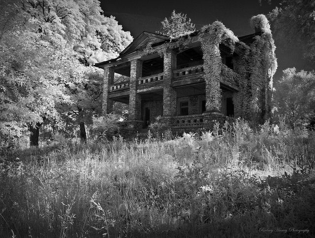
And then came the bulldozers and crews of workers to level and demolish every scrap of human habitation, burning and scooping out the earth to push rubble from the demolitions into. They were thorough. So very thorough. But, don't let the sight of lonely, empty gravel roads on your next visit fool you. There were homes all up and down this road in 1940, children were playing, chickens scattered under feet going about the chores and tasks of everyday life, crops of corn grew tall from fertile bottom land in the little meadow by Wet Fork Creek, and somewhere....always...you could hear the voices of our ancestors, and their laughter. My Aunt Marie reminds us from her memoirs, in the quiet of the evenings you could hear the gurgling waters of Otter Creek through the chorus of whippoorwills. And when our family gathered to sing on those warm summer evenings, the neighbors all up and down the little valley would assemble on porches to listen and sometimes, to chime in, music and song resonating beautifully, hauntingly, in the stillness of the night air.
While our heritage may not be tangible as in ownership, when we assemble for the next reunion September 5, 2015 we should all take pride as our eyes and senses absorb the panorama provided in this little valley...and in reflection on those that lived here, loved here, laughed here. toiled here, fought and died here....and whose very DNA flows in the blood of every single one of us.
Keith
Copyrighted by the author, Keith Wayne Ragan and contents may not be published or reproduced without his written authorization. The content is intended for family members and they may reproduce as desired for private family collections or ancestry trees.

Comments
Post a Comment